Sprint ⬥ Friday 18th April 2025
Sprint ⬥ Friday 18th April
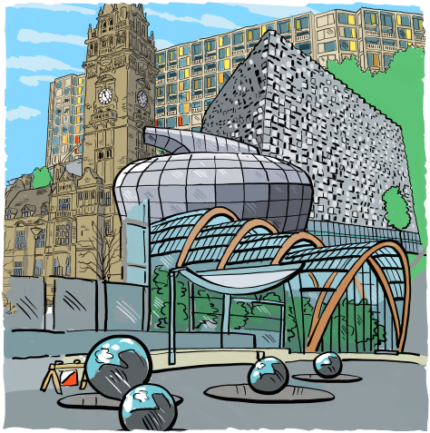
Sheffield City Centre
Based in the Peace Gardens in the heart of Sheffield City Centre, you don't get Sprints more central than this!
Competitors will explore the diverse urban terrain of the Steel City, passing through several centuries-worth of retail and industrial developments, as well as residential areas including the iconic Park Hill Flats, before finishing in the shadow of the Town Hall.
With intricate building shapes and passageways, mixed with fast running sections, but also some climb to contend with, Sheffield city centre offers the perfect sprint orienteering area.
Charlotte Ward
Important Notices
- The City Centre will be busy with shoppers, Snooker World Championship preparations, Football supporters and Easter celebrations.
- All competitors must show respect and consideration for other users of the area. Competitors must also follow all marshals' instructions.
- The buses and trams are still running on Good Friday, along with other traffic, but most will not affect runners.
- Please take note of the area-specific Safety Instructions below, including warnings about e-bikes and trams
- Those driving certain older vehicles should take note of the Clean Air Zone (CAZ) on and within Sheffield's Inner Ring Road - see Travel below
- Dogs are allowed in the Peace Gardens, but only Assistance Dogs in the Town Hall.
Overview
The area for the JK Sprint encompasses the majority of the City Centre, highlights of which include the Theatres, Fargate shopping area and Cathedral Quarter. The embargo also includes areas north and west of the Centre, such as Sheffield Hallam University's City Campus, Parkhill Flats and Victoria Quays Canal Basin.
The Arena will be in the Peace Gardens: Google MapsApple MapsWazeSK353871jukebox.local.shut
Some facilities such as Enquiries will be inside the Silver Room of the adjacent Town Hall.

Travel
Select a button to view travel directions
Sheffield is well served by public transport links: Sheffield Train Station is 700m away from the Arena, the nearest Tram Stop (Cathedral) is just 400m away (follow the marked route to the Arena), and most Bus routes terminate in the Centre. Please note that due to the Good Friday Bank Holiday, Sunday timetables will be in operation. See Travel South Yorkshire for more information.
Park and Ride
Park and Ride options are available using Sheffield's Supertram either alighting at Sheffield Station or Sheffield Cathedral Tram Stops.
Local people walking to Sheffield City Centre are advised to enter via Eyre St and Furnival Gate and follow tapes to assembly.
Sheffield City Centre has a comprehensive cycle network. View a map of Sheffield's Cycle Routes and Information about Cycling in Sheffield.
Sheffield is well served by the M1 to the east of the City Centre with options to exit at Junction 33 from the South and Junction 34 from the North. Follow signs for either the Park and Ride (if using), or Sheffield City Centre for Car Parks. There will be no road signage to the event.
Suggested Car Parks in the City Centre are:
- Q Park Charles Street - easiest for Disabled access
- APCOA: The Moor
- Atkinsons
- Arundel Street
- Matilda Street
- NCP Wellington Street
- NCP Furnival Gate
- Pennine Five
Sheffield Clean Air Zone
Please note that a Class C Clean Air Zone (CAZ) is now in operation for the heavily most polluting vehicles driving on, and within, Sheffield's Inner Ring Road (see CAZ map here). Vehicles liable to pay for entering the CAZ include some 4x4s and SUVs; check if your vehicle will be charged.
Directions for Campervans are the same as for Cars, though some Car Parks and Park & Rides have height restrictions. Please refer to the Sheffield Park and Ride and Car Park websites for details of height restrictions.
Larger Motorhomes
For those with larger motorhomes the Millhouses Park East Car Park (£4 all day) does not have marked bays. There are buses into the City Centre from there. Please be mindful it will be a bank holiday service though.
There is free roadside parking on the city-bound carriageway of the A621 to the north of Dore and Totley Train Station (north of this point). Competitors could then take the short train ride to Sheffield Station.
Alternatively, the streets around Kenwood Road in the leafy Nether Edge suburb have wide streets with no parking restrictions, but there is an approx. 3 km walk to the Arena from there, uphill on the return to your vehicle.
For further advice, please contact the Organiser via the Contact Form.
Sheffield Clean Air Zone
Please note that a Class C Clean Air Zone (CAZ) is now in operation for the heavily most polluting vehicles driving on, and within, Sheffield's Inner Ring Road (see CAZ map here). Vehicles liable to pay for entering the CAZ include some 4x4s and SUVs; check if your vehicle will be charged.
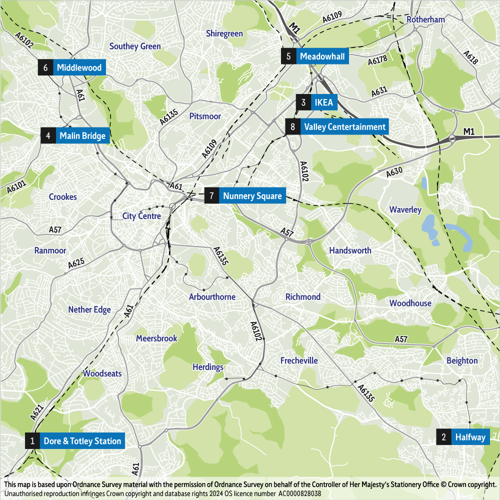
Accommodation & Parking in the Embargo
Given that the JK25 Sprint is being held in Sheffield City Centre, it is inevitable that competitors and their families may be booking accommodation in the area embargoed for the event.
The nature of sprint competitions is that the controls are usually very obvious; the challenge is executing the routes between them. Seeing a few controls in the area is usually of very little help.
On the morning of the event we would ask competitors, in the spirit of fairness, not to wander around the competition area but to proceed straight to the Assembly area. The same applies to those arriving by public transport or parking in the City Centre. Having deposited bags and picked up your bibs in the Arena, you should follow the taped route to your designated Start.
The embargoed area may be seen on the map below:
Updates
Tues 15th: minor updates to some Course Details (± 100m) - see update
Event Schedule
| 09:00 | Car Parks and Park & Ride open |
| 09:15 | Enquiries & Trophy Return open |
| 11:00 | First start |
| ~15:00 | W21E last finisher |
| 15:00 | Last start |
| ~15:15 | M21E last finisher |
| 15:30 | Courses close |
| 15:45 | Prizegiving, Awards and Medal Ceremony |
| 17:00 | Enquiries closes |
Day Sponsors


Arena
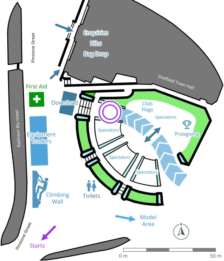
The Arena will be in the Peace Gardens, with the adjacent Sheffield Town Hall hosting Bib collection and Enquiries, offering the services listed here.
As the city centre is open to the public, please ensure that bags are stored safely whilst out on your run, and ideally have someone to keep an eye on the bags. An area within the Town Hall has been provided for those wanting to store their bags inside.
Club flags are permitted on the grass in the Arena, and we invite clubs to bring them closer to the podium for prizegiving, as indicated on the diagram. No club tents due to space limitations.
British Orienteering will have an information tent, and Compass Point and Altra will also be in attendance.
Owing to the number of food outlets (cafes, supermarkets etc.) close to the Arena, there will be no additional event food traders.
True to the Outdoor City name, we will be providing a Climbing Wall in the Arena, which everyone 1.2+ metres in height can have a go at for free.
Model Area
A model area is provided near the Arena with example controls. Maps at 1:4000 and 1:3000 are available at Enquiries. The model event has 4 SIAC controls. Do not forget to switch off your SIAC by punching the Finish. Please place maps in the boxes at the Finish, or hand to another competitor.
Under 16's must be accompanied by an adult if undertaking the model event as there are minor road crossings.
Starts
There are two Starts, as detailed below. Please follow tapes to the Starts, and observe the out-of-bounds to avoid walking into the event area.
| Start | Courses | Route | Details |
|---|---|---|---|
| Near Start | 6 to 17 | 0.2 km | Due to the small area that the Near Start is in, please don’t arrive too early. |
| Far Start | 1 to 5 | 2.2 km | The route will have some tapes, but there will also be a map available from Enquiries. The route will not be marshalled, but all road crossings are at light-controlled pedestrian crossings. Portable toilets will also be available here for competitors. |
Please note the Late Start policy: late starters will punch a Start box, but will be timed from their original Start time unless they are late through the fault of the Organiser.
Because of time-limited access to an area on Courses 1 to 5, there can be no extensions to the start window due to delays in arriving at the event. Please ensure you leave plenty of time for your journey, bearing in mind there will be extra traffic.
Timed-Out Road Crossing
Whilst competitors will cross multiple roads there is a road crossing for competitors on the Far Start where we have felt that it is necessary to control the crossing for some of the courses.
Courses 1 & 2: Competitors can cross the road at an angle but should take care.
Courses 3 to 5: Competitors will have a marshalled, timed-out road crossing between 2 controls. If the road is clear they will be allowed to cross immediately but should take care as the traffic, including bikes, can be moving quite fast. If there is traffic they may be held by the marshal until the road is safe to cross. In the interest of fairness, whilst waiting to cross and when crossing the road competitors should not study their map; any found doing so will be disqualified. Don't forget to punch on both sides of the crossing!
Safety Instructions
Due to the nature of the event area, there is a high marshal presence to ensure the safety of competitors and members of the public.
Marshals will be placed at potential risk points to warn competitors and pedestrians.
You are expected to take care to avoid other competitors, and to respect other users of the area; be prepared to slow down and pass in single file if necessary. Specific care is to be taken when you cannot see clearly, and take corners widely.
There are delivery cyclists on e-bikes in the competition area which competitors may encounter; please cross cycle lanes and roads with caution.
Please be cautious when crossing tram tracks and bus lanes, and listen to marshals' instructions.
Map
Numerous sprint and urban events have occurred in Sheffield over the years, and maps can be seen on the SYO Routegadget. Urbans in 2019 and 2021 were the most recent events that visited parts of the JK Sprint area.
The map is to ISSprOM 2019-2 IOF Specification, unless otherwise stated. Scales are 1:4000, or enlarged to 1:3000 as appropriate for some courses, with a 2.5m contour interval. Survey and cartography by Ian Cooper (SYO) 2023/25. All maps are A4 size, and are digitally printed by BML on waterproof paper. Some courses have Control Descriptions (CD) printed on the rear of the map, as indicated in the Course Details table below.
Terrain & Mapping Notes
Compared with university campus events, this City Centre Sprint presents different challenges for competitors. There are some heavy traffic roads which are mapped as out of bounds and which can only be crossed by under or overpasses or at manned crossing points; other roads have traffic, including taxis and buses, and should be crossed with care. There are tram lines with 2 tracks that can be crossed with care (look both ways as trams are quiet) except where shown with olive green. The trams slow down approaching stops and are generally running slowly in the competition area. Sheffield is also promoting cycle use so there are dedicated cycle paths in many areas.
There is a central shopping area, some of which is pedestrianised, the World Snooker Championships are taking place in the competition area and football fans may also be in the centre as Sheffield United (whose ground is about 1.5km from the assembly area) kick off at 17:30, so there will be many users/pedestrians/cyclists who are not orienteers. Please be courteous and compete with care. Many courses will encounter some of the above obstacles so be prepared and act sensibly - remember that pedestrians, as well as orienteers, do not always act rationally. We cannot adjust the event timings because of traffic delays.
Sheffield also has much construction work underway into 2025. The event map will be as up to date as possible.
Otherwise this is a typical urban area with roads, paths, open spaces, steps and multi-level areas. There is much street furniture, such as flower pots, defibrillators, benches and signs, with only the larger more significant features individually mapped. Roads are shown with pavements, which may include cycle lanes where they are significant. There are significant slopes in Sheffield and where buildings and car parks have been built into slopes the contours reflect the relief of the running surface, so if the running surface is flat there are no contours.
Junior courses involve no road crossings except at manned crossings.
Bus shelters are not shown but larger tram shelters are mapped as canopies.
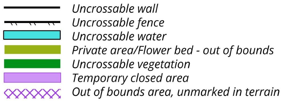
Special and Uncrossable (forbidden to cross) symbols are shown belowon the right.
Special Symbols

Forbidden to Cross Symbols
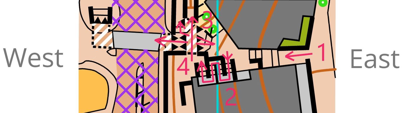
Underpasses under heavy traffic out of bounds roads (so there is only one running level) are mapped using the canopy symbol for clarity, with normal multilevel mapping where there are passable footpaths (see below for an example of the mapping, where there is an upper level passable footpath north of the out of bounds road).
There is a section of overhead tramway that has been mapped similar to below so that the ground level detail can be shown. The tramway is out of bounds on either side of the airbridge.

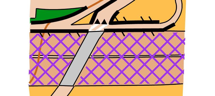
There are two specific complex set of stairs, which are shown below. In both cases the land rises from the east to the west, and east to west arrows point uphill.
There are two specific complex set of stairs, which are shown on the right. In both cases the land rises from the east to the west, and east to west arrows point uphill.
Example One
The climb is mainly up steps that are open to the sky.- steps up from pavement to first floor level passage, which is covered by a canopy
- steps from first floor level west up to higher level
- from underpass exit south up steps to street level or to west
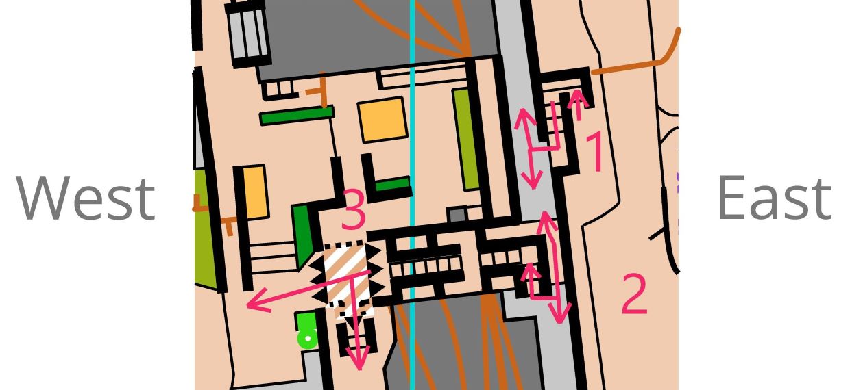
Example Two
- steps up from street level. There are then alternatives to reach the higher western street level: either
- use a zigzag set of steps to then exit to the north (arrow 4 over an underpass) or south, or
- head west up steps and through an underpass, where you can exit north up steps or carry straight on using an underpass under an out of bounds road
Course Details
| Course | Classes | Start | Distance (km) | Climb (m) | Controls | Map Scale & Info | Tech Diff |
|---|---|---|---|---|---|---|---|
| 1 | M18 M20E M21E | Far | 3.9 | 40 | 21 | 1:4000 | 3 |
| 2 | W18 W20E W21E | Far | 3.5 |
40 | 19 | 1:4000 | 3 |
| 3 | M35 M40 Men Open | Far | 3.5 | 50 | 20 | 1:4000 | 3 |
| 4 | M45 | Far | 3.4 |
40 | 22 |
1:4000 | 3 |
| 5 | M16 W16 | Far | 3.1 | 40 | 21 | 1:4000 | 3 |
| 6 | M50 | Near | 3.1 | 60 | 20 | 1:3000 Double-sided |
3 |
| 7 | M55 W35 | Near | 3.1 | 50 | 21 | 1:3000 CD on back |
3 |
| 8 | M14 W14 | Near | 2.7 | 30 | 22 | 1:3000 | 3 |
| 9 | M60 Women Open | Near | 2.7 | 35 | 20 | 1:3000 CD on back |
3 |
| 10 | W40 W45 | Near | 2.5 | 35 | 16 | 1:3000 CD on back |
3 |
| 11 | M65 W50 | Near | 2.5 | 30 | 19 | 1:3000 CD on back |
3 |
| 12 | M70 | Near | 2.5 | 20 | 19 | 1:3000 | 3 |
| 13 | W55 W60 | Near | 2.3 | 20 | 14 | 1:3000 | 3 |
| 14 | M75 W65 W70 | Near | 2.1 | 15 | 15 | 1:3000 | 3 |
| 15 | M80 M85 M90 M95 W75 W80 W85 W90 W95 |
Near | 1.9 |
15 | 18 | 1:3000 | 3 |
| 16 | M12 W12 Novice Adult | Near | 1.6 |
15 | 18 | 1:3000 | 3 |
| 17 | M10 W10 Novice Junior | Near | 1.3 | 10 | 17 | 1:3000 | 2 |
Clothing & Footwear
Shorts and running vests are permitted for this race. Shoes with spikes and metal dobs are not allowed.
Prizegiving
We aim to start the prizegiving at 15:45 with the WRE Flower and Medal ceremony. This will be followed by the British Orienteering Volunteer & Mapping Awards and the 2024 UK Orienteering League presentation. The JK Sprint Medal Ceremony will conclude the prizegiving. Please stay to show your support.
Acknowledgements
Our thanks to Welcome to Sheffield and the Canal and Rivers Trust for their help in staging the Sprint. Thanks also go to Pennine Five and Fountains Precinct for permission to use their sites.

Officials
Planners - Pete Tryner & Tim Tett (SYO)
Controller - Ranald Macdonald (DVO)
Assistant Controller - Andy Preston (SYO)
Mapper - Ian Cooper (SYO)
Organiser - Susan Guy (SYO) ![]()
Assistant Organiser - Brownwen Doyle (SYO)
IOF Event Adviser - David Rosen (SROC)